For light detection and ranging (lidar) scanners, the returns are in – and they’re good. Innovations have made lidar scanners, which emit laser pulses and capture the returning light to determine distance to an object or characteristics of air, smaller and lighter in weight than ever. Their resolution has improved, as has their ability to capture more returns per pulse.
Lighter scanners are a good thing, said Nicholas Ferguson, business planning and development manager at Network Mapping Ltd. in Chobham, UK. “The weight of lidar scanners has significantly decreased. This allows helicopter systems to take more fuel onboard – and the on-task survey time is therefore longer.”

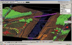
Mounted on a helicopter or plane and flown over terrain, a lidar scanner produces a high-resolution 3-D point cloud of what is below. The data then can be classified into objects, with the information used to lay out power lines or to see where vegetation needs trimming. Courtesy of Network Mapping.
Network Mapping’s primary business involves the electricity transmission industry, with customers in both the US and Europe. Using lidar scanners and photographic equipment, the company surveys sites before and after power lines go in, employing either a helicopter or a fixed-wing aircraft. The data is used for routing and designing new lines, accurately recording existing lines and tower locations, and spotting infringing vegetation.
Typical resolution requirements are for greater than 15 points per square meter. Sometimes, the ability to collect multiple returns per pulse is important because it allows profiling the canopy, subcanopy, understory and ground surface of a forest.
All of Network Mapping’s lidar scanners are from Optech Inc. of Vaughan, Ontario, Canada. Ferguson said the weight of systems has dropped by more than half in the latest products as compared with earlier ones. Up to four returns can now be captured per pulse, double the number possible earlier. The repetition rate also has increased, with the latest scanner emitting 200,000 pulses per second.
Brent W. Gelhar, vice president for sales and product strategy at Optech, pointed to the light source to explain these improvements. “In the last five to seven years, there’s been a revolution in what’s available in lasers.”
Diode-pumped solid-state lasers, for example, have matured, yielding systems with better reliability and less heat waste. The latter is significant because less heat means the system can be smaller and lighter. Advances in fiber lasers also have been important.
A few years ago, Optech launched a vehicle-based mobile mapping system – its Lynx product line. Being on the ground instead of in the air allows for higher resolution. It also makes for less expensive surveys because a truck or van costs much less than an airplane to purchase and operate.
Gelhar noted that the point density of scanners is increasing, leading to denser data on the ground. This trend will drive a merging of existing imaging technologies, such as cameras and hyperspectral imagers, with the 3-D time-of-flight measurements from lidar.
The result could be a new type of imager, he said. “By being able to merge this – and we’re already doing it with some of our systems by integrating these cameras with lidar systems – you’re basically going to true 3-D imaging.”
Catching a breeze
Most lidar systems operate in the infrared for improved eye safety and to maximize range. However, those wavelengths minimize interaction with some atmospheric constituents, which is why Michigan Aerospace Corp. of Ann Arbor uses 355- and 266-nm lasers.
“The primary advantage is being able to take measurements directly from air molecules,” said Peter Tchoryk Jr., the company’s CEO.

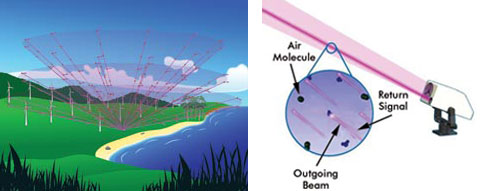
Because UV light interacts directly with air molecules (above), a direct-detection lidar scanner can provide simultaneous measurement of wind speed, direction, temperature and density over a large portion of a wind farm, potentially allowing operators to maximize energy production by matching blade configuration to changing conditions (left). Courtesy of OptoAtmospherics and Michigan Aerospace Corp.
Near-IR lidar systems detect scatter from airborne aerosols. However, these are absent when clear air is present, which is the case for large parts of the ocean, after a heavy rainfall or at higher altitudes. By operating at shorter wavelengths, lidar does not need aerosols to be present to determine wind velocity, air temperature or density. The first comes from the Doppler shift of the return, while the other two derive from the return’s width and intensity.
These measurements could be useful for getting the most energy out of the wind. Operators need to know where to situate wind turbines, so site surveys are important. To reduce the mechanical load and optimize energy production, they have to adjust turbine blades in response to gusts, shear and changing wind direction. Their need for more accurate short-term forecasts has been identified as one of the major problems for wind energy, Tchoryk said.
He added that the company’s products also could be used to spot clear air turbulence. Better techniques than those currently available to spot the problem are being researched.
Advances in lasers have helped Michigan Aerospace build better products. However, Tchoryk said, a laser with more power in the ultraviolet and with a narrow linewidth, single-longitudinal mode would be beneficial.
One of the company’s lidar systems can be found on Mauna Loa Mountain on the Big Island of Hawaii. There, the National Oceanic and Atmospheric Administration runs an atmospheric observatory. John E. Barnes, the observatory’s director, said the site’s three lidar systems, one of which is from Michigan Aerospace, provide data on such things as particulates, wind speed, air density, water vapor, ozone levels and temperature. A variety of wavelengths and techniques are used.

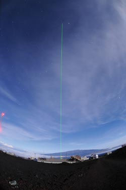
A wide-angle lens and a scientific-grade CCD enable camera lidar, which, unlike standard lidar, can measure particulates with high resolution near the ground. Courtesy of John E. Barnes, NOAA, and Joseph Shaw, Montana State University.
One scheme being developed for particulate measurements is dubbed “clidar,” or camera lidar. In it, a laser beam is fired vertically upward while a scientific-grade CCD camera equipped with a wide-angle lens snaps a picture from ~100 m away. The image of the beam traversing the air is then evaluated pixel by pixel. This simple approach has some advantages over other techniques, Barnes said. “The clidar measures all the way to the ground, where it’s got great resolution.”
The bottom of the world
For a final look at where lidar technology may be headed, consider a commercial product under development and a research project. The former leverages telecommunications gear, while the latter hopes to help the environment.
Mark Neal, an optical engineer with ITT Space Systems Div. in Fort Wayne, Ind., noted that telecommunication lasers are mass-produced, highly reliable and long-lived. Thus, they are well suited for a lidar scanner designed to be flown in a plane, a sometimes harsh environment where electrical efficiency, compactness, ruggedness, reliability and longevity are important.
These conditions inspired telecom components to form the basis for the Multi-Functional Fiber Laser Lidar developed by ITT in a technology incubator program funded by NASA. The development group demonstrated the lidar scanner over urban terrain and various types of countryside. They did this using a near-IR beam. However, any part of the spectrum for which telecom lasers and detectors exist could be used, Neal said.
Lastly, a research program under way in Antarctica shows that it is not all about lasers when it comes to needed lidar advances. There the government-funded Australian Antarctic Division uses a custom-built lidar system to measure atmospheric aerosols. The data collected is being used to refine ozone depletion and climate models, said senior research scientist Andrew Klekociuk.
The scientists recently deployed a new laser, a line-narrowed Nd:YAG from Continuum Inc. of Santa Clara, Calif. This source will offer better shot-to-shot stability than the original and will assist in improving measurements of backscatter, depolarization and incoherent Doppler backscatter.
Ideally, the group would like to get a complete backscatter spectrum in real time, as opposed to the tens of minutes now needed. Achieving that, however, won’t depend upon a better laser. Instead, it will require a detector that can take thousands of contiguous exposures at high resolution and sensitivity in microseconds, Klekociuk noted.
“The ultimate device for our application would be an ultrafast electron-multiplying CCD,” he said.