Dr. Alexander F.H. Goetz, !%ASD, Inc.%!
Hyperspectral remote sensing, in which an entire spectrum is acquired at each pixel of an airborne or orbiting sensor, provides a more complete understanding of the Earth’s surface and is a tool for monitoring change.
Unlike multispectral imaging, hyperspectral technology makes it possible to identify surface materials while removing the intervening atmospheric signal. Its technology, methods and environmental applications have expanded steadily over the past three decades, and it is now feasible to move to the next stage and attain continuous global coverage to bring to bear upon our understanding of the planet the critical, quantitative measurement of change.
Spectral imaging began nearly four decades ago with the launch of Landsat 1. The promise of imaging spectrometry became apparent as a result of the first field spectrometer measurements. The original definition for imaging spectrometry was proposed by me and others as “the acquisition of images in hundreds of contiguous, registered, spectral bands such that for each pixel a radiance spectrum can be derived.”1 That is still a good way to define this technique. In that same paper in Science, Jerry Solomon coined the term “hyperspectral imaging.”
Early on, microprocessors didn’t exist, and image processing was carried out in large centralized computer centers. Despite these technical hindrances, researchers realized that, ultimately, it would be technically feasible to fly imaging spectrometers from aircraft and spacecraft and obtain laboratory like spectra that allowed for the quantification of materials on the Earth’s surface. Spectral data collected by hyperspectral sensors provides security in numbers and facilitates statistical analysis techniques.
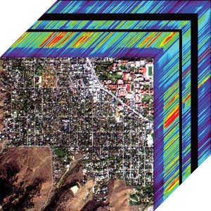
In this imaging spectrometer data hypercube, the colors represent the reflectance of the edge pixels in an image of Boulder, Colo. Low values are blue, high values are red. Courtesy of Joe Boardman.
The early years
Hyperspectral imaging of the Earth had its origins at the NASA Jet Propulsion Laboratory (JPL) following the 1972 launch of Landsat 1 (at the time called Earth Resources Technology Satellite, or ERTS 1). I was the principal investigator of a team – which included the late Gene Shoemaker – that was chosen by NASA to analyze Landsat 1’s multispectral scanner data for geologic mapping of the Coconino Plateau in central Arizona. During our image analysis, it became clear that subtle color variations shown on the images were difficult to identify on the ground and that spectral reflectance measurements of undisturbed surface soil samples would be necessary to properly interpret the image colors.
This need spurred the development in 1974 of the first truly portable field reflectance spectrometer (PFRS) that could cover the spectral range of solar reflected radiance, 0.4 to 2.5 µm. The results from the PFRS were instrumental in adding Band 7 to the Thematic Mapper and in creating the justification for the development of the Airborne Imaging Spectrometer at JPL, the first of its kind.
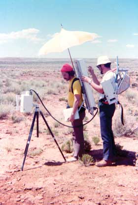
The instrument that began it all: Mike Abrams and the author, Alex Goetz, are shown using the first truly portable field reflectance spectrometer at the Coconino Plateau in Arizona. The instrument consisted of a circular variable filter and a PbS detector in the optical head, and control and recording electronics in the backpack. A spectrum was acquired in 30 s. The umbrella was necessary to shield the instrument from the sun. Courtesy of ASD Inc.
Imaging in spectral regions with pronounced atmospheric absorption features was first seen as a drawback of hyperspectral instruments. It became an advantage, however, as processing algorithms advanced to allow quantification of atmospheric transmission changes across an image as a result of elevation differences and water vapor variability.2 Because conventional multispectral instruments – such as those on Landsat and other spacecraft – do not image in these wavelengths, the ability to derive such atmospheric information is unique to hyperspectral sensors.
By the late 1980s, several commercial hyperspectral imagers had entered the market. The first was DAIS from Geophysical Environment Research of Millbrook, N.Y. However, by 1989 there still were no commercially available image processing software packages capable of handling more than 10 spectral bands. Additionally, software written on one platform could not be transferred to another without writing specific image display code.
In the early 1990s, the Spectral Image Processing System (SIPS) project undertaken at the Center for Study of Earth from Space, which I founded in 1985 at the University of Colorado, Boulder, developed the first image cube. It also developed hyperspectral image processing software that could be ported to all popular computing platforms of the time. SIPS later evolved into ENVI (Environment for Visualizing Images), which made it possible for relative beginners to process images.
ENVI stimulated the rapid emergence of a wider research community focused on the ability to accurately map terrestrial surface cover from space. However, one component was still missing: a readily available, truly portable field spectrometer for acquiring laboratory-quality spectra. Believing this ultimately would stunt the growth of the research community, my University of Colorado colleague Dr. Brian Curtiss and I developed a field spectrometer, now known as the FieldSpec line of analytical instrumentation, that could be used in a wide variety of research applications.
This original project prompted us to found ASD Inc. in 1990. For 20 years, the company has developed, designed, manufactured and sold the FieldSpec spectroradiometer. ASD’s sophisticated visible and short-wave IR instrumentation solutions and applications for materials measurement and research are used on every continent, in more than 1000 research institutions and in more than 70 countries.
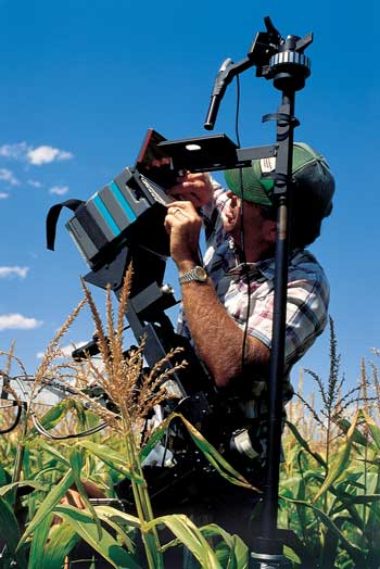
Hyperspectral research today: Walter Bausch, a water management researcher with the US Department of Agriculture, takes a white reference reading from corn using ASD’s portable spectroradiometer, PSII. Courtesy of ASD Inc.
Hyperspectral applications today
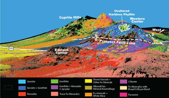
Applications for hyperspectral remote sensing cover the gambit of disciplines in Earth observations from water, rock, soil and plant analysis to ecosystem mapping. Hyperspectral images are used to map mineralogy in potential mining sites to understand the geologic history. Even the temperature of mineral formation can be deduced. An example is the Cuprite mining district, consisting of two acid-sulfate hydrothermal alteration centers straddling US Highway 95 in southwestern Nevada.3 Cuprite is one of the premier sites in the world for field testing the accuracy of new sensors and spectral mapping techniques because of its diverse alteration mineralogy, excellent rock exposures, sparse vegetation, dry climate and easy access.4 Using spectroscopic measurements, scientists determined that the area’s rich mineral diversity was formed during separate development of two hydrothermal centers at Cuprite. This finding has implications for mineral exploration and can be used to understand from afar the structure of other hydrothermal systems on the Earth as well as on other planets.
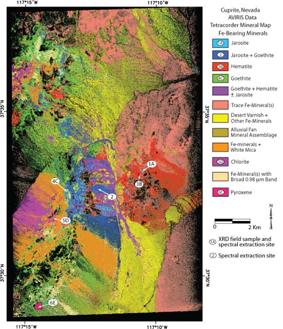
Above and right: The Nevada mining district Cuprite is one of the premier sites for field testing sensors and spectral mapping techniques because of its diverse alteration mineralogy, excellent rock exposure, sparse vegetation, dry climate and easy access for field measurements.
Indeed, hyperspectral remote sensing is continuing to expand to help us understand the Earth’s biosphere to match our increasingly sophisticated understanding of its physical and chemical systems at regional, continental and global scales. The National Ecological Observatory Network (NEON) is a platform for discovering, understanding and forecasting the impacts of climate and land-use changes and invasive species on continental-scale ecology. NEON will operate over the next 30 years and gather long-term data via high-resolution, regional airborne remote sensing observations.
The Airborne Observation Platform (AOP) carries remote sensing instrumentation designed to achieve ground resolution at scales from less than 1 m, bridging scales from organisms and individual stands to satellite-based remote sensing. Derived from a combination of a visible/short-wavelength-infrared (SWIR) imaging spectrometer, a scanning small-footprint waveform lidar for 3-D canopy structure measurement and a high-resolution airborne digital camera, AOP data will be available to scientists to study land-use changes and changes in ecological structures.5
The hyperspectral potential
The future of hyperspectral imaging falls into four categories. The first involves the trend toward acquiring even more accurate measurements, in space and time, of the state of the environment and its processes. The key question for hyperspectral proponents is whether important research and development dollars should continue to be put toward multispectral instruments such as the Moderate Resolution Imaging Spectroradiometer, or HyspIRI, the hyperspectral and IR imaging mission recommended in the 2007 National Research Council Decadal Survey. In the context of the cutbacks on NASA’s resources, is the potential knowledge worth the price? I think it is, but a strong advocate must come forward to assure that the allocation of these resources becomes a high enough priority.
The US is not alone in developing hyperspectral imagers for orbit. Among others, the German EnMAP mission, containing an imaging spectrometer that peers into the visible, near-IR and SWIR ranges, is slated for launch in 2015.
Second is the need to educate students to develop information and knowledge from the data. Currently, there are only a handful of university programs that teach spectral remote sensing, and analytical instruments suitable to support research efforts are expensive and hard to come by. Because of the need to access instrumentation, ASD each year presents select graduate students with the Alexander Goetz Instrument Support Program Award, which includes the use of a FieldSpec instrument for their field research, to further encourage a creative research environment within remote sensing and field spectroscopy. However, very few universities have access to instruments on aircraft. The potential exists, but it is doubtful that the field will expand significantly until a much larger group of students and faculty has ready access to hyperspectral imagers under its control.
The third trend is a positive one because of advances in computer and sensor technology that are providing easier ways to acquire, store, access and analyze large image datasets. Software and hardware evolutions are advancing hyperspectral imaging from the analysis of 100 km2 aircraft hyperspectral images to global datasets containing petabytes of data.
The final need is for hyperspectral imagers in orbit that can produce images of the quality and resolution of the Airborne Visible Infrared Imaging Spectrometer sensor and that can be used for characterization of the Earth’s surface and atmosphere with rapid repeat coverage. This data can then be applied to advance the fields of oceanography, environmental science, snow hydrology, geology, volcanology, soil and land management, atmospheric and aerosol studies, agriculture, and limnology, and can add the all important change element.
It is this passion to use technology to understand the planet where we all live that drives us forward. Tools such as airborne and spaceborne imaging spectrometers, field spectrometers and advanced chemometric modeling will continue to evolve in an industry that has yet to see its full potential.
Meet the author
Alexander F.H. Goetz is chief scientist and chairman of ASD Inc.; e-mail: [email protected].
References
1. A.F.H. Goetz et al (1985). Imaging spectrometry for Earth remote sensing. Science, Vol. 228, pp. 1147-1153.
2. J.S. MacDonald et al (2009). The contributions of Dr. Alexander F.H. Goetz to imaging spectrometry. Remote Sensing of Environment, Vol. 113, pp. S2-S4.
3. G.A. Swayze (1997). The hydrothermal and structural history of the Cuprite Mining District, Southwestern Nevada: An integrated geological and geophysical approach. PhD dissertation, University of Colorado, Boulder, p. 399.
4. R.N. Clark et al (2011). Mineral mapping and applications of imaging spectroscopy. US geological survey. Open-file report. http://webdocs.dow.wur.nl/internet/grs/Workshops/Environmental_Applications_Imaging_Spectroscopy/9_Clark_Mineral/IEEE_Clark_Mineral.pdf.
5. T.U. Kampe et al (March 17, 2010). NEON: The first continental-scale ecological observatory with airborne remote sensing of vegetation canopy biochemistry and structure. J Appl Remote Sens, Vol. 4, 043510.