Imaging systems and optical sensors are helping unmanned aerial vehicles (UAVs) find applications beyond the military.
Hank Hogan, Contributing Editor
Long familiar in a military setting, UAVs now are being used to map pollutants in the sky and to track wildfires at a distance. If some regulatory-related issues could be resolved, certain small UAVs equipped with cameras could be useful in a number of remote-sensing applications, ranging from law enforcement to inspection of infrastructure such as pipelines or power lines.

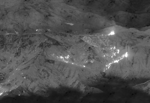
This infrared photo was taken by the US Navy’s RQ-4 Block 10 Global Hawk Maritime Demonstration aircraft during the Northern California wildfires in June 2008. To help the firefighters, the aircraft took more than 500 high-resolution, near-real-time images. Courtesy of the US Navy.
These and other applications are possible, in part, courtesy of imaging systems and optical sensors, said Bill Walker, the director of business development for Global Hawk, the high-flying UAV from Northrop Grumman, based in Los Angeles.
He explained that cameras have been placed in aircraft for a long time. What’s different, as well as what has made large and small UAVs so potentially useful, is a change in technology. “You can go down to the store now and buy a very high end camera with a CCD in it that is 10 megapixels or more,” Walker said.
Such cameras, which cost only a few hundred dollars, can take high-definition video. The ability to capture such images has been combined with wireless transmission over a variety of radio frequencies, including commercial Wi-Fi at 2.4 and five gigahertz as well as with technologies in the 900-megahertz band. Navigation technology and the aircraft’s capacity to travel along a specified route have improved, thanks to the widespread adoption of global positioning systems, which allow the position of a UAV to be known to within a few tens of feet.
The result is that even small UAVs now can give ground-based operators an accurate bird’s-eye view of a situation in real time. That advantage, combined with the craft’s ability to stay airborne inexpensively for a long time and to enter situations too dangerous for manned vessels, makes for a powerful capability.
Flying big
Although the Global Hawk and its ilk were developed for the military, they are being used for remote sensing elsewhere. For example, Northrop Grumman has teamed up with NASA to produce a fleet of environmental research UAVs. The payload of these large vehicles can be several thousand pounds, which allows them to carry sophisticated optics and imagers. Such capacity is vital because these aircraft can fly at high altitudes – in Global Hawk’s case, as much as 11 or 12 miles above the ground – and simply seeing in detail what’s happening directly below requires telescopes.

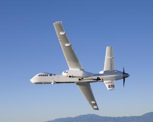
Carrying its sensor pod, NASA’s remotely piloted Ikhana unmanned aircraft banks away during a checkout flight in the Western States Fire Mission. Courtesy of NASA.
Not all of this sensing involves visual imaging, Walker noted. Northrop Grumman is working on remote hyperspectral imaging of water to locate and identify good and bad algae – important information for maintaining the health of seashores and the productivity of fishing. Another project, undertaken by the company in conjunction with NASA Langley, uses lidar to identify gases and particulates in the air. Because of their location in the sky, UAVs offer some unique information.
“From satellites, you can look down into the atmosphere, but you can’t tell exactly what layers are there,” Walker said. “With a UAV, you can look up, and you can look down. You can quantify the ozone and the things that are destroying the ozone.”
The company is also working with NASA’s Goddard Space Flight Center to characterize the density of clouds by flying through them. This data will help refine climate and weather models.
And small
A somewhat similar effort is under way at the University of California, San Diego, at the Scripps Institution of Oceanography, where a group led by atmospheric sciences professor Veerabhadran Ramanathan is using three autonomous UAVs to measure the incoming solar flux as compared with what actually penetrates the clouds. While one vehicle flies above the clouds or the layer being investigated, the other two fly above and below the first vehicle, stacked atop one another with a separation of less than 300 m. The information collected by the team is vital for modeling the impact of air pollution and greenhouse gases on people, the weather and climate change.
These studies are being done with much smaller UAVs than the Global Hawk or others of its kind. As a result, the total weight of the instrumentation payload is less than 5 kg; this roughly 11-lb package must fit into a shoe box, with lithium ion batteries supplying power.
Assistant project scientist Muvva Ramana helped design the instruments. He noted that a number of them employ lasers, sensors and other photonics technologies, including pyrometers that measure broadband radiation from 0.3 to 2.8 μm and photosynthetically active radiation sensors that measure the visible part of the solar spectrum from 0.4 to 0.7 μm. Whereas some instruments count particles optically, others use similar techniques to measure the number and size of cloud droplets. A camera mounted in the vehicle provides a visual record and also helps target specific clouds.
All instruments are standard commercial devices that have been removed from their housing so that they can fit in the available space. The team’s work has been ongoing, noted Ramana. “We have miniaturized several instruments in the last two years.”
In a paper published in the May issue of PNAS, the group reported that it had successfully used the UAVs in a 2006 study of the aerosol-cloud relationship over the Maldives – a good place to study the airborne pollution in Southeast Asia. The researchers found that constraints on the size of airborne droplets might lead to higher concentrations of droplets and greater reflectivity, which could be important factors in climate models.
A study over Southern California is ongoing, with flights running from April of this year until January 2009. Because of Federal Aviation Administration (FAA) regulations, all UAVs flying over the US are limited to military airspace – one of the reasons the number of UAVs is regulated. The FAA is working on rules allowing unmanned aircraft to fly without endangering the airspace. However, it is unknown when revised regulations might be issued.
Spotting wildfires
A final example of photonics being put to use for remote sensing aboard a UAV can be found in NASA’s Ikhana, a Predator B aircraft from General Atomics Aeronautical Systems of San Diego. As can other large UAVs, the craft can carry a substantial payload – some 400 lb of internal instrumentation and more than 2000 lb in underwing pods.

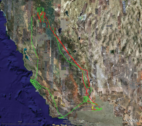
This image shows the flight paths of the NASA Ikhana unmanned aircraft during flights on July 8 and 19, 2008, as part of the mission to observe California wildfires. Each mission exceeded 1300 miles. Courtesy of NASA/Google.
The aircraft was pressed into service to supplement other thermal infrared imaging during California’s recent wildfire season, when hundreds of fires were burning. NASA and the US Forest Service had been planning a demonstration mission during the summer, but because of the need to combat wildfires, the demonstration was delayed. For the same reason, and to ensure safe operation, the FAA worked with NASA ground controllers while the UAVs were allowed into commercial airspace.
Everett Hinkley, liaison and special projects program leader with the Forest Service’s Remote Sensing Applications Center, noted that the sensors on the UAV capture more than just a burning fire when surveying a scene. They also image tin roofs and rocks, both of which can reach elevated temperatures when exposed to the sun. “We need to be able to get the parts of the spectrum that are capable of distinguishing the heat from the fires and to eliminate false detections from hot objects,” he said.

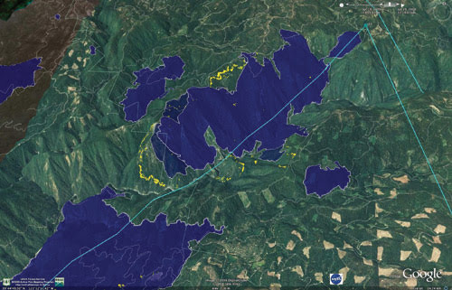
A wildfire instrument carried aboard NASA’s Ikhana unmanned aircraft captured this image of the Canyon Complex fire in Northern California on July 19, 2008. The yellow regions depict actively burning areas. The red, pink and blue tones map out burned areas. Courtesy of NASA/Google.
The other big need is to overlay the sensor image with actual ground coordinates so that firefighters can be directed correctly, so the sensor must have good spatial resolution. A captured visual image that firefighters and others can use to orient themselves is also important.
According to Jim Brass, co-principal investigator for the Western States Fire Mission at NASA Ames, the sensor aboard the Ikhana is a multispectral scanner that captures everything from the visible to the thermal infrared out to 12 μm. In the device are multiple detectors, many of which are based on mercury cadmium telluride, indium antimonide and silicon. Twelve channels of data are provided, and a spinning mirror paints an image across the landscape. As the UAV flies, more and more of the total image is captured.
Brass noted that the sensor package had been customized for the UAV through the addition of computing power and satellite communication – a modification required by the nature of the application. “It has to do a lot of processing onboard and handle a lot of decision making that used to come from an operator.”
The Forest Service’s Hinkley noted that, because of satellite communications, the data from the UAV can be on the ground and in the hands of those who need it within 10 or so minutes of acquisition. His experience so far has been a positive one. “The imagery that we’re getting is extremely good. It’s very, very useful,” he said.
That’s an assessment that could apply to a number of existing UAVs and associated missions. With continued development of photonics and aircraft technology, the sky literally could be the limit for these unmanned vehicles.
To Fly Like a Bird
Photonics technologies, in addition to providing remote sensing from the air, are playing a key role in the development of next-generation UAVs. Compared with today’s vehicles, the next generation’s may be much smaller and have the flying dexterity of bats or bees.
To create such high-tech UAVs, though, engineers must understand how such animals fly. Conventional aerodynamic theory says that they shouldn’t be able to, because their wings shouldn’t generate enough lift, particularly during hovering or slow forward flight. However, contrary to conventional theory, insects and bats do fly.
They accomplish this feat by generating a leading edge vortex – a swirl in the air that can increase lift substantially. Although it’s been known for some time that insects do this, it’s only recently been shown that bats use the same mechanism. Researchers from Lund University in Sweden and from the University of Southern California in Los Angeles used laser- and detector-based digital particle image velocimetry in a study of how bats fly. The group’s research shows that the generation of the leading edge vortex depends on the ability of a bat to make changes on demand to the camber, or curvature, of its wing.
This information could help in building a flying machine that flaps instead of using a more traditional approach. It also might be vital in designing a machine that stays aloft while expending less energy than formerly. Both of these characteristics could prove useful in building the next generation of smaller – and perhaps more batlike – UAVs.