Rescue agencies the world over have rallied
together in a bid to bring relief to the thousands of people left injured, homeless
and without food or sanitation in the wake of the Haiti earthquake, which devastated
the region in January this year.
One of most troublesome questions looming in the minds of many
Haitians and aid workers alike is the possibility of further tremors. The fear of
severe aftershocks is so real that, months after the quake, many people are living
in makeshift tents set up in open areas away from the danger of falling debris.
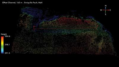
This displays the point cloud of lidar from the Rochester Institute of Technology airborne
system.
Crucial lidar-based mapping of Port-au-Prince and the surrounding
area is providing survivors and rescue workers with invaluable information about
the ground on which they find themselves trying to pick up the pieces.
According to an assessment of aftershock hazards carried out by
the US Geological Survey (USGS) at the request of the United Nations, the frequency
of aftershocks following this magnitude 7.0 earthquake will diminish with time,
but damaging earthquakes remain a possibility. There is also a small chance of subsequent
earthquakes larger than the initial shock.
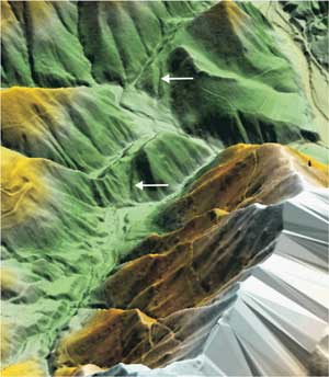
An oblique three-dimensional view of the Idrija fault zone derived from the lidar digital terrain
model (DTM) is shown. Arrows point to clearly defined fault segments. Courtesy of
Stephen Grebby.
The geologic fault that caused the Port-au-Prince earthquake is
part of a seismically active zone between the North American and Caribbean tectonic
plates, known as the Enriquillo fault.
“The Enriquillo fault represents a real threat; it has a
long-term slip rate of about seven millimeters per year and has, in its history,
experienced large and damaging earthquakes as well as the 2010 magnitude 7.0 earthquake,”
said Dr. Ken Hudnut, a geophysicist at the USGS.
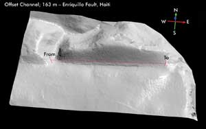
The images above and below show an old stream channel that appears to have been offset about 163 m left-laterally by the Enriquillo fault in Haiti. This feature will be checked by geologists in
the field and sampled to see whether material in the channel bottom sediment may
be datable by radiocarbon methods to derive a long-term slip rate for the fault
system. The current understanding of a slip rate of 7 mm per year is derived from
a model based on global position system station velocities. Using data such as this,
the USGS hopes to augment this information by obtaining a long-term geologically
based slip rate. USGS images by Ken Hudnut.
Airborne lidar surveys of Port-au-Prince potentially may reveal
the distribution of slip along the active fault in enough detail to enable the USGS
to establish whether the slip was caused by early historic or prehistoric earthquakes.
“High-resolution airborne and satellite imagery revealed
an absence of surface faulting,” Hudnut said. “The sections of the fault
to the east and west of the portion that broke in this earthquake seem to have not
broken since early historical events. This gives rise to a near- to intermediate-term
concern of a larger event on this fault system to the east or west of the section
that broke in the January 2010 event.”
This information is vital for the reconstruction effort currently
under way in the area, and the USGS is already planning follow-up assessments. Accurate
and up-to-date forecasts will help ensure that expectations are accurately set and
that any new buildings can be properly engineered to minimize damage caused by possible
future tremors.
Similar lidar projects are being carried out by the Leicester
Lidar Research Unit in the UK, in which airborne lidar is employed to map seismogenic
faults in densely forested terrain in the Julian Alps of Slovenia. In this area,
the forest is so thick that it obscures subtle surface traces of faults captured
on aerial photographs and also makes fieldwork logistically difficult.
Because laser pulses emitted by lidar systems can penetrate through
gaps in the forest canopy to reach the ground, scientists can build up a “bare
earth” digital elevation model (also referred to as a digital terrain model,
or DTM) by eliminating laser reflections deemed to originate from the canopy.
“This ‘virtual deforestation’ of the terrain
helps to reveal surface features and tectonic landforms of the fault systems in
unprecedented detail, which ultimately contributes to a regional seismic hazard
assessment program,” said Stephen Grebby, a research student in the geology
department of the University of Leicester.
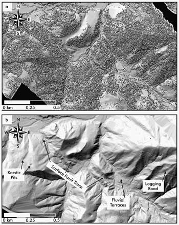
(a) Digital elevation model of the Idrija fault zone created using
lidar data points originating from both the ground and the forest canopy. (b) Lidar
DTM created through “virtual deforestation” reveals in unprecedented
detail the surface trace of the Idrija fault, along with many other surface features.
Courtesy of Stephen Grebby.
Both terrestrial and airborne lidar can provide geologists with
accurate and high-resolution information about the surface morphology over large
areas and in areas that would otherwise be inaccessible in the field. According
to Grebby, lidar data allows scientists to study and try to understand surface phenomena
in greater detail than was previously possible using more traditional approaches
such as field surveys, aerial photography or satellite imagery.
Grebby is working on another study, carried out in conjunction
with the British Geological Survey, in which lidar is applied to mapping in areas
where the spectral identification of different rock types is hindered by the presence
of vegetation. Rocks in the northern foothills of the Troodos ophiolite in Cyprus
are found to respond differently to surface processes, such as weathering and erosion,
according to their type and therefore typically have relatively distinct topographic
characteristics.
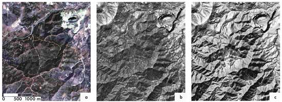
Airborne remote sensing data used for lithological mapping of the Troodos ophiolite, Cyprus.
(a) Airborne thematic mapper multispectral imagery, (b) Airborne lidar digital elevation
model and (c) Lidar DTM after “virtual deforestation.” Courtesy of Stephen
Grebby.
“I’ve been developing a methodology that describes
the topographic characteristics of the main rock types using morphometric variables,
such as topographic slope, roughness and curvature, derived from a lidar DTM. I
can then generate a lithological map of the study area by classifying according
to these topographic characteristics,” Grebby explained. “I’m
now investigating whether lidar-derived topographic information can be combined
with multispectral information to further enhance the lithological mapping performance.”
The business of lidar
Lidar is important not only to seismologists and geologists, but
it also is becoming big business for numerous market areas, ranging from insurance
services to mineral exploration. Over the past 12 years, mapping specialist Infoterra
Ltd., also based in Leicester, UK, has been using lidar to provide 2-D mapping and
3-D visualizations for a wide range of commercial companies.
“Typical commercial applications of lidar technology in
the UK include landscape modeling for flood risk analysis – this can either
be broad-area surveys at river catchment scale or very precise site-specific surveys,
for instance, modeling flood risk associated with electricity substations or similar
infrastructure,” said Dr. Anthony Denniss, chief operating officer at Infoterra.
Other applications include measurements around electricity power
networks to calculate the risk of vegetation encroachment upon power lines, as well
as to measure the curvature or “sag” of the power lines between each
pylon.
“This information allows power companies to calculate whether
individual lines are able to carry more power or not,” Denniss said.
But Infoterra’s latest application of lidar reflects an
emerging trend that is now beginning to embrace the technology – mapping cities
in unprecedented detail.
Infoterra is currently mapping the major UK city centers to provide
highly detailed models that are further enhanced by high-resolution oblique images
that are “wrapped” onto the sides of the buildings. The end result is
an accurate representation of the city that is useful for city planning, surveying
and architecture applications.
“The sensor that we currently operate is one of the latest
generation sensors, which means we can record a maximum of 167,000 measurements
per second as we fly,” Denniss said. “Depending on a number of variables,
such as flying speed, height of the aircraft above the ground and ground elevation,
this scanning frequency translates into a ‘points per square meter’
(ppm) measure on the ground. Typically, for rural areas we collect data at 4 ppm,
but for urban centers we increase this to 12 ppm, allowing detailed building structure
to be defined.”
Coming back down to Earth
At ground level, both terrestrial and mobile lidar tend to be
used where even more detail or precision is required, as both systems can produce
mapping data accurate to millimeters. For example, Infoterra opts for static terrestrial
lidar for precise engineering surveys, with a recent project involving the survey
of more than 300 UK motorway bridges ahead of road widening schemes.
Mobile lidar technology introduces a new generation of sensor
developed within the past few years specifically to operate on the roof of a moving
vehicle. According to Denniss, numerous mobile lidar systems are now being launched
but are best employed in applications such as road corridor mapping. And while these
systems are slightly less than a static system, they do offer other advantages,
such as being far more cost-effective, as long stretches of road can be examined
in a short period of time.
Collecting data on the move also eliminates the need for lanes
on highways to be closed while the survey is in progress, reducing traffic disruption.
In urban areas, mobile systems are allowing town planners to map the “as built”
environment in a way never before possible because of high costs previously associated
with data collection.
Lidar technology has enjoyed rapid development in recent years.
For example, when Infoterra purchased its first airborne sensor 12 years ago, it
was able to collect 5000 measurements per second (mps). Today, airborne systems
can achieve 400,000 mps, whereas terrestrial scanners routinely operate at 500,000
mps, with some close to 1 million mps.
This trend is expected to continue, while at the same time the
sensors themselves will become smaller and more power-efficient. And as more sensors
have appeared on the market, the cost of these systems has decreased in real terms,
making the technology more accessible, which in turn results in its being used more
routinely.
“Simple, low-cost sensors that were initially developed
for factory applications, such as for the control of assembly line robots, are now
making their way into the world of navigation,” Denniss said. “Research
projects to date have successfully demonstrated how data from these simple laser
sensors can be processed in real time and integrated into navigation systems, allowing
autonomous vehicles to be navigated around complex terrains.”
Coupling this with the growing trend to map everything in ever-increasing
detail could herald a new era of navigation and visualization services. “If
you think about it, most mapping of complex environments tends to be two-dimensional,
but now it is possible to cost-effectively map these same environments in high-definition
3-D,” Denniss said. “Once these high-definition 3-D mapping environments
become commonplace, it will open up a completely new era of navigation and visualization
services.”