Doppler Lidar Could Aid Weather Forecasting, Aircraft Safety
A dual-frequency direct detection Doppler lidar system could offer a simplified yet robust way to accurately measure wind speed. The detailed, real-time wind measurements provided by the system could help scientists better understand how hurricanes form and provide information that meteorologists could use to pinpoint landfall earlier.

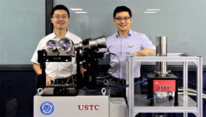
Mingjia Shangguan and Haiyun Xia from the University of Science and Technology of China were part of a research team who developed a new Doppler lidar system for accurately measuring the wind. It features a greatly simplified optical setup that makes it robust and stable enough to use in harsh environments such as aboard aircraft or satellites. Courtesy of the Quantum LiDAR Laboratory.
A research team at the University of Science and Technology of China (USTC) has designed a Doppler wind lidar that uses a superconducting nanowire single-photon detector (SNSPD) at 1.5 µm. Because this wavelength is commonly used in optical communications networks, the researchers were able to build the system using commercially available fiber-optic components. The all fiber construction of the lidar system makes it strong enough to withstand harsh environments and rough operation handling.
The optical setup for the Doppler wind lidar contains just one laser source, one detector and a single-channel Fabry-Perot interferometer that converts the Doppler shift into photon number variations of the backscatter signals. Using a Fabry-Perot interferometer made of optical fibers, rather than one consisting of many individual optical components, enhances the system’s stability, according to the team.
By using the time-division multiplexing method, the team needed to use just one piece of SNSPD in the optical receiver. This helped them develop a system that is simple and powerful at the same time. The simplified design of the lidar also makes it easier to configure and align each component and lowers the amount of light lost within the system.
The SNSPD is used to enhance the temporal resolution. Two telescopes are used to detect the line-of-sight wind components, which are then used to synthesize the horizontal wind profile.
“The high detection efficiency and low dark count rate of the SNSPD means that the weak signal from the backscattered light can be detected with a high signal-to-noise ratio,” said researcher Haiyun Xia. “Another attractive feature of the SNSPD is its high maximum count rate, which helps avoid detector saturation.”
The researchers demonstrated their Doppler wind lidar system’s ability to measure horizontal wind speed with high accuracy and showed that the system remained stable throughout a 10-day test period.
Overall, the system's measurements varied by less than 0.2 m/s over 10 days in the lab. Researchers also tested the system outdoors and compared its horizontal wind measurements with measurements from an ultrasonic wind sensor. On average, the lidar measurements were within 0.1 m/s and 1 degrees for wind speed and direction, respectively. Horizontal wind profiles up to an altitude of about 2.7 km were calculated with vertical spatial/temporal resolution of 10 m/10 s.
The new system requires no calibration after it is initialized and requires no special eye protection.
“For lidar systems that will be operated full-time in the field, eye safety is an important consideration,” said Xia. “Fortunately, the 1.5-micron laser we used exhibits the highest permissible exposure for eye safety in the wavelength range from 0.3 to 10 microns.”
The 1.5-µm wavelength is good for atmospheric wind sensing from satellites because, compared to UV and visible wavelengths, it shows less susceptibility to atmospheric disturbance and optical contamination from the sun and other sources.
Existing high-accuracy wind measurement technologies can be expensive and difficult to operate, leading to gaps in the application of these technologies in situations where they could be useful.
“We demonstrated a Doppler wind lidar with a simplified optical layout that also substantially enhances the system stability,” said researcher Xiankang Dou. “Although specialists are typically needed to operate and maintain a sophisticated Doppler lidar , we are confident we can develop our approach into a system that will be as easy to use as a smartphone.”
The researchers are now working to improve the spatial resolution of the Doppler wind lidar system and want to make it even more practical to use in the field. They have also founded a company to further develop the system and plan to have a commercial version available next year.
The research was published in Optics Letters, a publication of the Optical Society (doi: 10.1364/OL.42.003541).
Published: September 2017