Dr. Radu Barsan, Rio, Inc.
Spectroscopic, fiber optic sensing, and light detection and ranging (lidar) technologies increasingly are being employed in the wind and geothermal energy sectors; in making fossil fuel exploration, extraction and distribution as well as fossil-fuel-based energy generation cleaner, safer and more efficient; and in monitoring greenhouse emissions and pollution and their effects on the planet.
Photonic sensors play a major role in a sustainable future and, in particular, in a variety of applications in the generation, distribution and conservation of energy, as well as in the mitigation of the effects of energy production and consumption on the environment.
Electricity generation from wind energy is rapidly growing in the US and worldwide, and could provide at least 20 percent of the nation’s electricity by 2030. This trend is driving the need for larger multimegawatt turbines, for onshore and offshore utility-scale operation, with rotor diameters well exceeding 100 to 120 m. As wind turbines increase in size and capital cost, there is a growing need to incorporate early-warning wind shear measurements and turbine structural health monitoring to optimize the design, operation and maintenance of the wind turbine – and to protect it with a high level of confidence against dangerous wind gusts. At the same time, the high levels of investment required for the development of new wind farm projects drive the need for improved site assessments of the wind resources, over longer periods of time, to improve the confidence level in the returns on investment.
Because of their immunity to electromagnetic interference, lightning and electrical noise, optical fiber sensors have been steadily gaining in popularity among wind turbine manufacturers as a practical, reliable and cost-effective online structural safety and fatigue monitoring tool integrated with the condition-based monitoring system of wind turbines. Fiber Bragg grating (FBG) strain sensor arrays – either surface-mounted or embedded – can monitor the mechanical behavior of rotor blades in different types of wind turbines. The results can be used during the design and qualification stages to corroborate the measured strain values against design models. In service, premounted FBG sensors help monitor online the condition of the blades while rotating or stationary, and under various wind conditions.
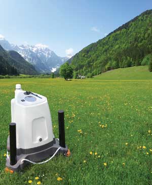
Lidar technology has been used for a long time in atmospheric research. Recently, it has been having a growing impact on the wind energy sector because, unlike mechanical anemometers, it can measure the speed of wind remotely. Laser radiation scatters from atmospheric particles (aerosols, dust, pollen, water droplets) and is Doppler-shifted by the wind. Measuring the Doppler shift can provide accurate speed measurements at distances ranging from tens or hundreds of meters to kilometers. By scanning the laser beam or using several telescopes at different angles, the wind speed vector components also can be derived in real time. Ground-based lidar, which complements wind flow modeling data, first penetrated the site assessment market as a valuable replacement for meteorological towers equipped with cup anemometers. Powered by reliable infrared lasers with a narrow linewidth, wind lidar operates nonstop over extended periods of time (months and years), taking and transmitting vast amounts of wind speed data from multiple points on a prospective site over many seasons, atmospheric conditions and altitudes (Figure 1).

Figure1. Commercial lidar wind-measurement systems are among the many tools used to keep an eye on the environment. Courtesy of Zephir Ltd.
Narrow-linewidth semiconductor lasers have become lower-cost, smaller and, most importantly, more stable and reliable. They can now operate maintenance-free on the nacelle for long periods of time. With the aid of these developments, turbine-mounted lidar instruments increasingly are being deployed to measure the magnitude and direction of the wind speed at hub height upstream of the turbine (typically 200 m). The supervisory control and data acquisition, or SCADA, systems of turbines equipped with wind lidar can now “see” the wind before it reaches the blades. The systems can take appropriate yaw and pitch control actions to either protect the blades from excessive gusts or maximize the efficiency of converting wind speed into generated power. This results in increased component lifetimes, increased turbine availability, and loweroperating and maintenance costs per megawatt of generated power.
Using lasers to monitor the environment
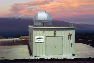
Thanks to their ability to remotely determine the speed and direction of air particles or molecules, atmospheric lidar systems are an instrument of choice for diverse environmental monitoring activities ranging from predicting the trajectory of volcanic ash plumes after a major eruption, to measuring global tropospheric wind fronts to help in weather forecasting (Figure 2).

Figure 2. This direct-detection fringe imaging Doppler wind lidar system is located near the summit of Mauna Loa in Hawaii. Courtesy of Michigan Aerospace.
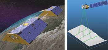
The extraordinary ranging accuracies that can be achieved with ultranarrow-linewidth lasers enable powerful space-based applications for environmental research and monitoring. For example, NASA’s GRACE (Gravity Recovery and Climate Experiment) mission maps the Earth’s gravity field by making accurate measurements of the distance between two satellites, using GPS and a precise ranging system (Figure 3a). The gravity variations that GRACE studies include changes due to surface and deep currents in the ocean; runoff and groundwater storage on land masses; exchanges between ice sheets or glaciers and the oceans; and variations of mass within the Earth. The results from GRACE contribute to global climate change studies. The GRACE-FO (GRACE-Follow-On) mission, planned for launch in 2016, will provide an ultralow-noise, frequency-stabilized laser interferometric ranging capability to the satellites. The GRACE-FO laser ranging will measure the distance variations between the spacecraft to the level of 1 nm, allowing a more precise determination of the Earth’s gravity field.

Figure 3. Left: Satellites fly in formation in the GRACE mission. Right: The ICESat-2 satellite uses a laser beam split to illuminate six spots on the ground. Courtesy of NASA.
Another application, ICESat-2 (Ice, Cloud and land Elevation Satellite-2), is the second generation of the orbiting laser altimeter ICESat and is also scheduled for launch in early 2016. Its scientific objectives are the following: quantifying polar ice-sheet contributions to current and recent sea-level change and the linkages to climate conditions; quantifying regional signatures of ice-sheet changes to assess mechanisms driving those changes and to improve predictive ice-sheet models; estimating sea ice thickness to examine ice/ocean/atmosphere exchanges of energy, mass and moisture; and measuring vegetation canopy height as a basis for estimating large-scale biomass and biomass change. ICESat-2’s ATLAS (Advanced Topographic Laser Altimeter System) instrument is a multibeam laser altimeter that uses time of flight to map out the topology of the Earth (Figure 3b).
Oil and gas exploration and production
Over the past decade, optical fiber sensors have gained widespread acceptance within the oil and gas industry due to their reliability, flexibility and low operating costs, as well as the benefits brought by their multipoint and distributed sensing capabilities. Initial applications have focused on downhole, single-point bottom-well temperature and pressure sensing, as well as distributed temperature and strain reservoir sensing. More recently, extensive interest has been shown in the development and commercialization of fiber optic seismic and acoustic sensing arrays – land and underwater – for oil and gas exploration, pipeline surveillance, geophysical monitoring, reservoir monitoring and management, geothermal monitoring, and structural monitoring of offshore platforms and oil tankers. Photonic sensors contribute directly to making hydrocarbon exploration and production cleaner by helping avoid spills, reducing the number of required drillings per oil field, and making oil and gas transportation and distribution safer and less polluting.
Initially, fiber optic sensing (FOS) was introduced in the oil and gas industry as a replacement for legacy electronic temperature and pressure gauges, as well as a tool to monitor nonconventional reservoirs and enhanced recovery in wells through distributed temperature sensing using either FBGs or Raman backscattering techniques.
FOS technology, having undergone the incubation period required to prove its field-worthiness, is now ready to be widely deployed in more advanced applications such as pipeline monitoring, leakage detection, high-temperature geothermal wells, intelligent completions and flow assurance – among others. The development of reliable commercial ultralow-noise semiconductor lasers that can operate maintenance-free from desert to arctic conditions has enabled dynamic acoustic sensing based on coherent Rayleigh backscattering technology. Distributed temperature and strain sensing, on the other hand, is being addressed with Brillouin optical time-domain reflectometry or Brillouin optical time-domain analysis techniques. Distributed acoustic sensing (DAS) enables detection, discrimination and location of acoustic events on an optical fiber over tens of kilometers.

Figure 4. Fiber optic sensing systems: Left: A commercial distributed acoustic sensing monitoring system in operation. Courtesy of QinetiQ. Above: A distributed temperature sensing data acquisition unit installed in a thermal recovery field in the Middle East. Courtesy of Qorex.
Using a combination of the measurement of backscattered light and advanced signal processing, the DAS interrogator segregates the fiber into an array of thousands of individual “microphones.” Applications of DAS are common in pipeline monitoring, intrusion detection, hydraulic fracturing of tight sand and shale gas reservoirs, and passive or active seismic reservoir monitoring (Figure 4).
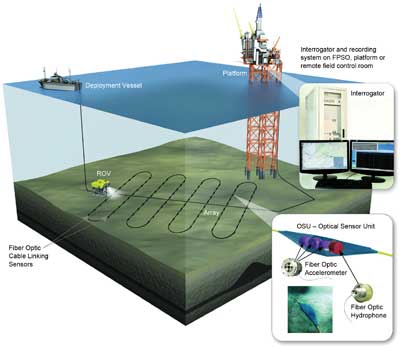
Seismic permanent offshore oil reservoir monitoring is an important and growing application of interferometric FOS technology, with significant contributions to the upstream oil and gas industry (Figure 5). The seismic data is used for monitoring and mapping fluid movements and pressure changes in oil and gas reservoirs, and for identifying bypassed compartments, monitoring flood fronts, planning infill drilling locations, and monitoring fracturing and stimulation operations – all of which contribute to greener utilization of assets.

Figure 5. A fiber optic seabed seismic sensing system. Courtesy of Stingray Geophysical.
Processes, emissions across energy sectors
In the conventional energy sector, optical and photonics-based gas sensors and sensing techniques are effective, practical tools for the detection, assessment and localization of fugitive gas emissions and leaks – such as hydrocarbons and sulfur hexafluoride (SF6) – in chemical plants, refineries, power plants and gas pipe-lines. The technology also plays an important role in detecting and quantifying gas emissions, volatile organic compounds and pollutants – from hydrogen leak alarms for fuel cells and hydrogen stations, to moisture in natural gas lines; it is also used for monitoring combustion efficiency and emissions in fossil plants. Detection systems are based on techniques such as Fourier transform infrared, Raman spectroscopy, cavity ring-down spectroscopy, differential optical absorption spectroscopy, photoacoustic spectroscopy and tunable laser absorption spectroscopy.
Fugitive emissions in refineries result when hydrocarbon vapors leak from process equipment such as valves, flanges, pumps, compressors and other equipment, and from the evaporation of hydrocarbon spills in open areas. The total quantity of fugitive volatile organic compound emissions in a typical refinery, with a capacity of 330,000 barrels per day, is estimated at 45,000 pounds per day. Fugitive emissions are typically invisible and oftentimes poisonous or flammable. They are also common in the electric power industry. Sulfur hexafluoride is an effective electrical insulating gas frequently used in high-voltage gas-insulated switchgear, transmission lines and breakers. However, SF6 has an extremely high impact on the greenhouse effect – more than 23,000 times more severe than an equivalent amount of CO2 – and has a lifetime of 3200 years. SF6 can be emitted from leaking substation equipment, or can be released during servicing and refilling operations.
A significant portion of greenhouse gases are produced by the energy sector, with the largest pollutant contributor being CO2 from coal-fired power plants. This is precisely another application where photonic sensors – tunable laser absorption spectroscopy gas monitoring systems – are making an impact by performing in situ, real-time measurements of O2, CO, CO2 and water vapor in two dimensions across the boiler flame zone to help improve the combustion efficiency.
Meet the author
Dr. Radu Barsan is president and CEO of RIO Inc. of Santa Clara, Calif.; email: [email protected].